SIGHTINGS/ IDENTIFICATIONS: Spider, Yellowbelly Water Snake, Crawfish, Wasp with Nest, Creek Nymph
RUN: 6-7 Miles
Difficulty: Easy to Moderate
RATING: 5.65 for great swimming hole, visible creatures, history of the beatles.
WEATHER: Sunny, 80º to 90º F
TYPE OF TRAIL: Medium dense Long Leaf Pine, Loblolly Pine Forests, Creek side paths. Light Elevation changes.
WALK THRU: I went up to Birmingham Alabama to sell a car and stayed over night with some friends, Chuck and Tressie. Having a day off out of town during the summer, I knew this was the perfect time to get in a quick day hike. Sharon drove her car up with me in case the car was sold so I would have a ride back home to Florida. The night before our hike, I read about a great trail reminiscent of the Appalachian range along side a river with a place known as the Devil's Den along the way. "Devil's Den", I couldn't pass this up!
We headed east of Birmingham to Talladega National Forest and after going through some crazy forest roads we punch the clock at Lake Chinnabee Recreation Area. We grabbed the packs and immediately hit the trail, it took us along the Cheaha Creek. Not far along the trail we came across a small leg of the creek and looked down to find a little crawdad. It was just sitting there out in the open. I must admit I am a bit of a crawdad-a-saurus. I was wondering to myself why some lucky animal had not come and eaten this gem. Drooling and crazy eyed, I gently put the crawdad back into the very small creek, hoping, promising myself if it was there when I got back then it was meant to be.
Further up the trail we ascended slightly in elevation to reach a look out point. This wooden structure allowed us views of the Talladega National Forests tree tops and the Cheaha Creek below. From this high vantage point we noticed some amazing waterfall rock formations below with pools of water. We headed down the path and scrambled down rock wall to the creek's edge. Immediately, we saw a snake fall into the water and swim away. Note to self: Snakes are here.
Sharon and I decided to do a little exploring and we had brought our Canon Rebel Xti with us to do some of the dirty work, take the pictures, that is. Across the creek Sharon spotted a snake hanging out on a tree branch. At first I could not make it out so we got a little closer for a photo op.
Water Snake
As we were admiring the Snake, we found a wasp nest hanging from a branch over the water. Sharon shot some pictures of the wasps as I fled over rocks to avoid getting stung.
After we finished playing with the creatures we decided to take a dip. Just up the river about 20 yards we found DEVILS DEN! Devil's Den was a large, deep swimming hole on the creek. The water was clear, but due to the rock being a dark color it looked endless. Shaking off good advice from our parents, we climbed to the top of the rock, 15 ft above the water, and jumped in. The water was cold but felt good on this hot summer day.
Sharon poses as a River Nymph.
Going for a swim at Devil's den.
After swimming for a half hour we got back to the trail. Along the trail were little posts with information cards, these posts informed us that Talladega National Forest used to be primarily Long Leaf Pine but after over deforestation and an invasion of the southern pine beetle, the number of these trees decreased to almost nothing. Loblolly pine was planted in the area to replace the Long Leaf Pine and this caused the endangered Red Cockaded Woodpeckers numbers to fall dramatically. These birds use mature Long Leaf Pine trees for nesting spots. Due to conservation efforts, populations of both the tree and bird have been restored.
We continued to hike, now gaining slightly in elevation once again. The landscape reminded me of the Foothills Trail a little, only replace the Chattahoochee River with a small creek. I guess that river makes a big difference as far as excitement goes. Our hike climaxed in elevation as we hit the Cheaha Falls Shelter. We looked around the shelter for a bit a decided that this would be a great place to camp. It sits at the top of a Small Mountain/Hill overlooking the country side. Just below is the Cheaha Creek where the running water is music to your ears. It's also great for refilling your water as you set up camp for the night. This area is not a complete bald by any means but the tree canopy is pretty spread out in the area so I am guessing star gazing would also be great here at night.
We hit our halfway point just past the shelter at the Cheaha Falls. The falls were lovely, but large orb weaver spiders were hanging around everywhere. We had to watch out for the eight legged creatures as we hopped from rock to rock. Sharon practiced filtering water for fun along part of the falls. After admiring the view and the cascading water, we decided to turn around because the sun was setting. We quickly made our way back to the car. We made record time getting back to the parking area and decided to take a short stroll around the lake. Sharon and I found out that the area has an amazing campground, with lots of fish in Lake Chinnabee. If I am ever back in the area this would be a great place to camp with some friends.
Also, as we passed back by the leg of the creek I saw what looked to be a large frog hoping away with that delectable crawdad.
TRAILHEAD:Lake Chinnabee Recreation Area - From Talladega, travel 7 miles northeast on State Road 21, 12 miles east on County Road 96, 2 miles southwest on Forest Service Road 646.
LESSONS LEARNED: -Alabama has some really great hiking trails worth checking out. - Carmax, the used car purchasing company, will not give you a good deal on your used car in Birmingham Alabama so you only need to take one car, not two. -Kia is the worst car company in the world and Carmax knows it, so don't buy one in the first place.
SIDE NOTES:- For longer hiking options or over nighters consider linking Chinnabee Silent trail with the Pinhoti trail and the Skyway trail. -The Cheaha Falls Shelter was awesome. It has a great view, just up from the water, One of the nicest if not the nicest shelter I have ever seen. -Some where in the park Archaeologists have found rock shelters and evidence of habitation from the early Archaic Period. SICK!
MAPS/ CONTACT: USDA Forest Service
National Forests in Alabama
2946 Chestnut Street
Montgomery, AL 36107
Phone: 334-832-4470
Picked up the book below in town and used the map inside. The trail is well marked and pretty self explanatory if you decide you don't need the book as a resource. I had trouble finding a map online.
SIGHTINGS/ IDENTIFICATIONS: Gafftopsail Catfish, Red Drum, Southern Stingray, Striped Mullet, Atlantic Sharp-nose Shark, Bottle-nose Dolphin, Blue Runner (Hard-tail Jack)
RUN: 11 miles paddling open water.
Difficulty: Moderate to Challenging
RATING: 8.25for amazing wildlife and seclusion.
WEATHER: Rain, Strong Wind, 90º to 70º
TYPE OF TRAIL: Sand, water, slight chop up to 1 ft. waves, shallow grass beds to deeper channels.
WALK THRU: Chris and John S. were telling me about a new kind adventure I might be interested in, a canoe trip or an adventure where you have everything you need on you, but you travel by water. Fort McRee is where just such an adventure would take place. It is located directly across the pass from Ft. Pickens on a thin sliver of island known as Perdido Key. Ft. McRee was built to protect the natural harbor during war time and unlike Ft. Pickens, it is only accessible by foot or boat. I have heard that even when traveling by foot, if the tide is high than the hike can become quite wet. Up until this point, I had never participated in an outdoor adventure that involved me putting all my gear in a boat and rowing to my destination.
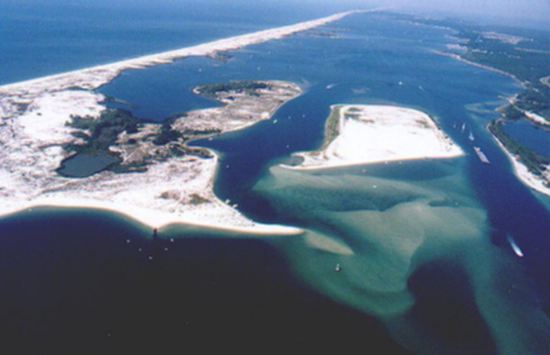
The Eastern End of Perdido Key.
Day1- With all of our gear in tow, the Perdido Key Expedition Team headed for our sandy egress. We arrived at Perdido Key State Park in the early afternoon, paid our 3 USD per car and informed the Park Ranger that we would be primitive camping on the tip of the Key. Our kind Park Ranger explained that we would need to arrive back the next day before sunset to get out of the park before the gate closed and locked. He noted that crazy tropical thunderstorms strike often on the Gulf Coast, leaving seafarers with no shelter from the storm. I asked the ranger for a weather update and he informed me that there was indeed supposed to be a few light showers in the morning. When asked what to do in case of a lightning storm on the beach, the ranger told us to stay as low as possible and stay away from taller objects like trees and the metal fort. He added that they recently had someone struck by lightning in the Park.
The road that runs through the State Park only stretches about a quarter of the island. There is no parking at the end of this road, for this reason, our group had to drop the canoe off at the last wooden walk way to the Big Lagoon (left side) along with all of our supplies. We pretty much weighed the canoe down to capacity. We had camping gear for four people, along with fishing poles, equipment for catching a shark, food, copious amounts of water, and three adult human bodies. Chris said that he had put much more weight in the canoe on previous trips and that as long as there were no large waves we shouldn't sink to the bottom of the ocean floor.
John S. launched his sailboat at the boat ramp, which is located just past the park gate on the left hand side. His boat of choice was his tried and true Sunfish. This is a small 1-2 person sailboat, basically a large surfboard with a sail on it, only slightly more stable. John had to sail an additional 2 miles but the wind was good and he quickly gained on us as we paddled our barge of equipment 5 miles out to the pass. Quick note- the pass is an area of water between the two barrier islands where the Gulf of Mexico flows into the Big Lagoon and the Pensacola Bay. During the Gulf's high tide the water flows into the bay, during low tide it flows back out into the Gulf. For this reason, there is not only a variety of fish but high traffic in schools of fish. It's an amazing fishing spot, but many people cannot reach it if they don't own some sort of boat.
John's Sunfish Sailboat
Along the way we encountered a scary moment where some large waves from a barge threatened a capsizing. It was exciting to be on such a small boat in the water. Our vessel was man powered, our strength and oars kept us moving as we paddled swiftly through the waters. With no buildings and roads on the land to our starboard side, it felt like we were the first ones to discover the eastern end of the key. It was certainly an adventure for me and Sharon as it was our first canoe trip with everything we needed for two days right there in the boat, and we were camping on gorgeous beach that most people never get to go to.
Chris, the captain of the canoe, is a master rower. He can move any kayak or canoe more quickly and accurately than any person I have ever met. With his strength and speed and a little help from Sharon and me, we glided quickly past grass beds, marshes, and lagoons. Soon we reached what I believe is called Dolphin Island. As we rowed through this tight channel we could see the dolphins herding schools of fish, which did not bode well for the fishing part of our expedition. At times, we got to see these marine mammals up close. These particular Dolphins were masters of the water, they had barnacles and shells crusted around their heads, they were decorated as chieftains. Another five minutes of paddling and we made land just past Ft. McRee at the tip of the island. To the east we could see Ft. Pickens, to the South was never ending blue, the Gulf of Mexico. We unloaded the canoe, caught some bait with our cast nets, and got right to the fishing. Our goal for the trip was a dream of Chris', to catch a gigantic shark. He immediately put some good sized bait out in the water, set up his poles, and waited. The fishing was consistently slow for most of the night though. John S. caught a very large Sail Cat, probably around 2 pounds. As the sun began to set, Chris caught a small Atlantic Sharpnose Shark, which he returned to the sea. Although I say "small shark", it was still 2-3 feet, big enough to bite a hand or a couple of fingers off, which leads us to "How to Handle a Shark"!
HOW TO HANDLE A SHARK: When you first catch the shark be sure to noose the tail with a rope. You don't want to grab the tail because sharks are flexible and can twist and bite you. You want to grab the shark just behind the dorsal fin and remove the hook. You should use some kind of long pliers to remove the hook, usually 6-12 inch extension. Avoid touching the sharks gills, touching them causes bleeding in the gills and is harmful to the shark. -I have heard you can turn sharks upside down and this will put them into a calm state where they will not bite you. Please comment if you know anything about this. Big sharks should be returned to the water quickly as larger sharks use up all their energy during the fishing struggle. Small Sharks should be placed into the water, not thrown, as this will kill them. Move the shark back and forth to get water moving through the gills until they become responsive, try not to get bitten.
Notice the tail is in a Noose knot.
Night 1- The night slowly came without any of us really noticing and after we quit getting bites we decided to get some shut eye. We didn't want to waste the opportunity of possibly catching a fish during the night so we cast our lines once more, plunged our rod handles into the sand, and set our drags low so we would be able to hear fish taking out line from our tents. At one point in the night, Chris had something take line out, and if I remember correctly, it must have been a beast because it snapped the line right off. Maybe that was a dream.
Chris w/ cast net, Perdido Key. Photo by Jon Bollhoefer
Day 2- We woke up early and in a mad dash we set out to catch a monster. Chris and I headed over a couple small dunes to another stretch of beach while Sharon lingered in camp and made some coffee. John S. was still passed out in his tent. Sticking out of the pristine beach was a rock and cement jetty, it was here that we decided to fish for the morning. Little bait fish were swimming in and around tiny ponds made by the rocks. Sharon joined us on the jetty after a while and tried to catch more bait. Catching fish takes a little bit of work though. You have to constantly catch bait with a cast net and keep that bait alive by changing out the water in your bait bucket. You have to make sure the line on your poles stays tight and check the bait on your line every once in a while to make sure nothing has stolen it. In the middle of mastering this process, the sky on the horizon behind us turned an ominous dark gray. Ten minutes later we were in the middle of a serious storm. Huge rain drops started hammering down on our heads and we all rushed to get our camping gear into our tents and out of the rain. As we did this, the wind picked up and the thunder and lightning came with it. Having a natural fear of lightning I decided to return to the jetty to bring my poles in. Then I sat in a low spot in the sand where I figured I could wait out the storm. Sharon decided to join me.
Chris fishing, Perdido Key. Photo by Jon Bollhoefer
As we sat there we looked to the top of a nearby dune and sighted a very odd object through the hard rain and wind. It looked like a gigantic kite of sorts blowing in the wind. A large yellow and gray plastic bag was tightly wrapped around what looked to be some sort of figure. "That's interesting," I recalled my tent being the same gray and yellow. CLICK. I immediately realized that the colored kite now approaching me was in fact my tent. Then I thought, "Why is John using my tent as a rain jacket?". Apparently, without sand spikes my tent had uprooted and started to blow away into the water. Furthermore, it would have drifted out into the middle of the Gulf of Mexico with all of my camping gear in it, but luckily, John S. was nearby and had grabbed the tent. Since a tent is basically a giant wind flap, it had turned John into a human kite and he was walking slowly to keep from blowing away. Once we realized what the situation was, we quickly disassembled John from the tent and stuffed it into my hiking pack. Sharon and I then continued to sit in a low spot by a dune, terrified of the electric spark discharges happening in the atmosphere. The rain was somewhat painful on bare skin due to the hurricane force winds and the drops left millions of tiny craters in the sand.
Chris and John S. decided to keep their poles out while there was lightning all around, and not only keep them out, but hold their fishing poles in their hands, often turning and yelling over the sound of the rain to me "we're not scared, you have nothing to worry about." Meanwhile, I was bragging about how well my rain jacket was working and using Sharon as a human shield from the lightning, praying that the storm would pass soon. The lightning and thunder passed and left us with a light but steady rain that continued the rest of the afternoon.
When the lightning let up I got back to fishing. We saw fish attacking the water and at times saw what looked to be a large shark attacking schools of fish by the jetty, but we had no luck. We were still having fun though. Chris played on the rocks in the jetty and admired the aquatic wildlife. He showed me a small damsel fish called a Sargent Major. The fish had beautiful bold yellow stripes, they are normally found in coral reefs. Chris explained to me that he sometimes scuba dives for these small fish and other similar species for his saltwater aquarium at home.
Sergeant Major
By this time we were all starting to get hungry. We went to start up the stove to cook some pasta but found that our equipment had been soaked in the mini hurricane. Our cooking equipment was dry but all of our lighters were wet and we couldn't get one to light a spark. After nearly mashing our thumbs raw on the lighters we decided to check out the old fort. The four of us marched inland over the hills of sand. We came across the fort's exterior wall and climbed onto it. The wall had sand on one side and bramble bushes on the other. We walked atop the wall until there was a gap in the thorns, there we jumped off and headed uphill towards the fort. After we explored all around the abandoned historic building, we set up a tarp between a couple trees. Sharon had found a dry lighter and under the makeshift shelter we lit the stove and cooked up some pasta.
The rain stopped. As we were sitting up near the Fort we had a great view of a cove below. It was half way between our campsite and the fort, visible on the map below. Chris and I noticed something tearing up the water and we grabbed our poles to go check it out. When we got down to the water it was complete chaos. Along the whole shoreline of the beach and cove was an ENORMOUS undulating school of minnows. They were being herded into the shallows by predator fish that kept the tiny fish constantly running for their lives. It was an amazing sight. I don't remember exactly what happened next, but I cast my line and madness in sued. I know I had a series of large fish on and then off the lines, getting big hits from presumably large game fish. Chris yelled to me to reel in slow and that's when I got a big hit. I hooked into a small monster. As I reeled it closer to the shore I realized it was a red fish. I had to land this fish. I hadn't caught a red fish of legal keeping size before and about a minute later I pulled it ashore. It measured in at 19 inches, a keeper! We continued to fish, not wanting to waste this golden opportunity. Looking down at the water, I noticed the humongous body of small brown to red minnows. This moment was similar to a scene in the movie Life Aquatic with Steve Zissou, where he sees the huge school of Fluorescent Snapper before the Jaguar Shark kills Esteban. Large fish were flying in from the deeper areas of water and taking multiple minnows at a time. Chris at one point jumped into the water and had a gigantic speckled trout at his feet. All I could see was Chris yelling loudly and freaking out followed by obscenities. Later, I found out that he almost grabbed the biggest Speckled Trout he had ever seen with his bare hands but just missed it. It was a lunker for sure. After this we stayed high from the catch for quite some time not realizing that we had to row back in the canoe before it got dark.
The adrenaline rush eventually wore off. All of us were still soaked to the bone from the constant drizzle, our fingers and toes were a little pruney. We began to fix the damage that was done to all of our equipment during the storm. Tents were dried off, hiking bags were emptied and we laid everything out in the sun to dry a little before we departed. It was nice to get a little sun but during these summer months after it rains it becomes very humid and the bugs become quite bad, so that was a small downside. I fished a little more before we headed out and caught a few Hard Tail Jacks, which Chris used as shark bait. Excited about catching some more fish I kept casting in hope of another big one, but ultimately we needed to get back to the car.
At the end of the day, Chris practically had to drag me back into the canoe. We began to paddle back to the car but this time the tide was moving against us, making it a little more difficult. John, using the power of wind, tipped his hat to us as he sailed past as if to say, "ha ha, you poor bastards." Most of the trip back we paddled over sea grass beds and the water was surprisingly clear. We could see everything. As we moved further into the Big Lagoon we would approach large marine wildlife and it would explode in the water, swimming away quickly before we could identify it. A couple of times we encountered gigantic 2 to 4 foot stingrays. It was crazy when they spotted us rowing over them, they would panic and the calm silent water would break as the fish scattered away. Once we passed the grass beds the wind really died and we made our way more quickly to the loading beach. Unfortunately, John S. was still stuck out on the water and what before was a calm sailing day turned into a row-a-thon as he raced the setting sun to the loading dock. Chris helped him row the sailboat back to boat launch. Also, knowing that we would not make it out before sunset, Chris acquired the combination number to the locked gate so we would not be stuck in the park for another night. Great Job! We loaded the cars up and headed out.
TRAILHEAD:Perdido Key State Park is located 15 miles southwest of Pensacola, off State Road 292.
BODY CONDITION: Great Condition, maybe a little soggy.
LESSONS LEARNED: When camping on the beach its always a good idea to bring sand spikes for your tent. Normal tent spikes will not do the job if there is a storm. -Before you play make sure your necessities are secured from wind and rain.
SIDE NOTES: -Pull up to boardwalk unload then park car. -The park gate closes at sunset. You may be able to acquire the combination if you get back just before dark. -Fishing in Florida requires a license, make sure you know limits and regulations as rangers will check your cooler. Fines can be expensive and rangers may confiscate your fishing equipment.
MAPS/ CONTACT: Perdido Key State Park 15301 Perdido Key Dr. Pensacola, FL 32507 (850) 492-1595
TYPE OF TRAIL: Rocky ridge lines. Scrambling, Steep rugged strenuous rim trails down into the gorge. Primitive, undeveloped trails through wildold growth forests. Dense hardwood and pine. A incredibly wide variety of terrain, just see for yourself.
WALK THRU: Day 1- SPRING BREAK!!! The drive to Linville took longer than expected, mainly because my car broke down on the way there. The battery died so I bought a new one and Steve and Elijah installed it. It took us about an hour to drive up the mountain because we somehow took the long way and the roads were winding and bumpy. We were also in a 1989 Toyota Corolla hatchback, a vehicle not exactly engineered for backwoods navigation. Just before we hit our anticipated destination, our cars were blocked by a "closed for the season" gate. Now our unit of comrades had to walk up to the parking lot where we were supposed to begin our journey. The seven of us piled out of the warm cars and stretch our cramped appendages and take pee breaks. Before we abandon the vehicles for our four day adventure in the wilderness, we chugged some water, and paused to enjoy a beautiful view. It's of a valley opposite side of the gorge, fog was rising up the slopes and we felt like we were above the clouds. We got our first scent of that sweet mountain air.
Night 1: We hopped the closed gate one by one and sealed our fate. First was Steve, our hiking enthusiast/ park ranger. Second was Dana, our flight medic/ militant nurse. Steve and Dana are married and in peak physical condition. Next in the convoy was Lydia and Sharon, the twins who love to cook and make art. Elijah was our gargantuan blacksmith, eagle scout, maverick. Tamara was the honorary hippy-yoga aficionado/ anthropologist. I bring up the end of the group as the amateur hiker/ college art student. We had begun our hike.
No one seemed to notice at first but, after the first several yards of hiking, we realized that this road to the picnic area was kind of steep. We were starting to wonder just how much further it was going to be to the picnic area. The road seemed to get a little more lofty with each bend, and there were many bends. I was ready to conquer this hike though and was not going to let a little incline stop me. At this point, Lydia had an brief anxiety attack and started hyperventilating. This was her first big hike and I think the thought in her head was, "If the rest of the hike is nearly as hard as this steep paved road, I am not going to make it and I am going to be stuck in a wilderness area where no one can save me." Seemed perfectly reasonable to panic to me. Little did any of us know that she would be right. After a little TLC we got up to the picnic area where we were greeted with bear signs and dumpsters. Paranoia. By this time it was very dark, cold and out of nowhere we got hit with a snow storm. Everyone rushed to set up their tents, meanwhile, I was constantly looking out for bears with my headlamp. Sharon, Elijah and I made pesto pasta in the shelter of a restroom wall nearby. Steve and Dana just retreated to their tent for the night to avoid the cold and snack on some energy bars. Lydia, exhausted from her stream of consciousness, passed out in the tent without dinner and Tamara followed her. Elijah proved his Eagle Scout skills and started a small fire out of some wet wood and kindling. We watched the fire for a few minutes but we were soon overcome with sleepiness and so we headed to bed. Sharon and I snuggled into our bags but sleep was elusive this night. While I remained warm and in my down 20 degree mummy bag, Sharon tossed and turned from the cold in her cramped, child sized bag. Through out the night, our body temperature warmed the frozen ground beneath us, creating a large puddle under our tent that would undulate like a water bed with each small movement.
Day 2: The next morning we awoke hoping that every one's spirits had improved with the fresh day. We all enjoyed a breakfast of hot oatmeal and coffee. Steve, Dana, Sharon, and I hiked up to the top of the Table Rock (3,680 ft) for some quick views in the morning. On one side of the trail you could see a drop off where rock climbers usually scale the mountain. We spent probably 30 minutes on top because the views were so amazing. You could see the Blueridge Mountains for miles and miles. Linville Gorge is just below and we could make out the Linville river as it cuts through the terrain leading to lakes and a city in the distance. Table Rock was called "Attacoa" by the Cherokees, who used the mountain as a mystic alter for their sacred ceremonies.
Table Rock
The Table Rock Summit team arrived back at picnic camp. Steve and Dana had to leave a day early so they wanted to get a head start on the trail. We decided to meet up for Night 2 and camp together, but afterwards we would split into two teams. From now on Steve and Dana will be referred to as Team A. Elijah, Lydia, Sharon, Tamara and I will be referred to as Team B. Team A drew a map on a piece of paper and set out. Team B was moving slowly and we did not get out of camp until noon. The five of us set out on the Mountains to Sea Trail, from Table Rock to the Cambric Branch Trail, we hiked along a bald ridge line. There were steep drop offs on both sides of the trail and the path was rocky and rugged. At one point there was a spectacular natural rock tunnel that we had to scramble through. I felt like I was in 5th grade again, sitting there on the couch watching GUTS. For a moment there we were those indestructible kids with knee and elbow pads.
GUTS
The trail began to turn from rock to dirt as we entered a small wooded ridge line. Hiking through this area, we passed a rock formation known as the Chimneys. From the Chimneys we descended a jagged 1000 feet to chimney gap and promptly rewarded ourselves with a break. As we sat munching on trial mix with our heavy packs cast on the dirt floor, a man with nothing but walking sticks and a small camelback hotfooted past us, walking at a speed of about 3 to 4 miles per hour (very quickly). I remember thinking how good it must be to have only 5 to 10 pounds on your back.
We checked the map and realized our path to go down into the gorge should be coming up soon. Finishing our little rest, we hoisted on our packs and shoved off. As we reached the top of a small bluff I noticed a couple of rocks piled on top of each other and a trail leading off to the left. This was supposed to be the Cambric Branch trail, although it was somewhat confusing as there was no actual sign for the trail. Apparently, the mound of rocks was the only trail sign we would receive, so our group turned left and began to follow the path into the gorge. At this point I should note that we were running low on water so walking down to a mountain river seemed like a good idea.
As we started to descend I realized that this trail was becoming mildly coarse. At first it was just really steep. Soon the trail started to open up into a large wooded area, the steep ground was completely covered in a thick sheet of dead leaves. The sight was beautiful, a hundred shades of brown and gold stretched before us. To our misfortune, the trail was somewhere beneath this knee deep sea of dead leaves and it seemed as though all the trees with our trail blazes had fallen sometime during the winter. The way was treacherous. We slid down yards of hill on the slippery leaves, we hurtled over logs and ducked under the downed trees, all while hoping there were no unseen obstacles laying under the thick blanket of leaves. Half way down the monstrous hill we found a couple of bright pink blazes that assured us we are heading in the right direction. The path then changed from a steep bed of leaves to very steep dirt plunge. The soil was not stable making it hard not to fall down this descent. You walked and simultaneously slipped down the muddy surface, some of us kind of scooted down on our butts.
The Trail marked in red is not the trail we hiked. Our trail
was the Cambric Branch in Blue. Notice the elevation change.
We hiked a little further on and once again we lost the trail. This time we really had trouble trying to find it. For a moment I sort of had a complete meltdown in my brain. We are out of water and I have seen one to many episodes of Survivor Man. Luckily from watching these shows, I knew getting anxious is bad and I needed to calm down. No one else really seemed to be worried. Plus, we could hear the water just below us so I knew one way or another I could just walk towards the sound of water if I had to. We kept group B in one place while Elijah looked around for a trail marker, he found one with in a few seconds. Turns out there was nothing to be worried about the entire time. It's weird how your brain can panic like that. I thought to myself, one little freak out like that mixed with some delirious bad decisions could be an equation for some really stupid mistakes. So we made our way further down the trail and as we did the sounds of gurgling water drew closer and closer. I thought for sure we should be there by now. All of us were tired from hiking down the extremely steep terrain, 1500 ft in 1 mile. We approached a small ravine with a stream flowing through it. The only way over this obstacle was an entanglement of dry branches and downed trees that created a sort natural bridge. We forced our way, climbing over and through these trees to cross to the other side of the ravine. Once we were all safely across, we finally made our way down to the river.
At the river's edge we found Steve and Dana's packs and plopped ours down beside them. We sat down on the stony shore and ate a lunch of crackers, cheese, and salami. Steve and Dana had hiked down the river to try and find a safe crossing area or a bridge. Upon their return, they found us filling our faces with crackers and reported that there were no bridges for crossing. Immediately in front of us there was a really deep pool and further up river were waterfalls. However, there were a few parts of the river that were wide and shallow nearby. When we finally decided on the section of water to cross, it was 5 o' clock and starting to get cold in the gorge. The water temperature in the river was ice cold so we decided to wait til the next morning to cross.
Sharon and I decided to take a walk along the river since the waterfalls and views were so beautiful. On the way back we found a demolished tent. Basically, it looked like a very nice blue tent, expensive, with high quality poles- only completely shredded to pieces. It looked like who ever was sleeping in that tent was mauled by a bear. Usually, if someones tent is damaged they bring it home and repair it, right? Creepy. Jokes are made about the tent and unlucky traveler, wood is knocked on after wards. If anyone reading this knows the story behind the tent, has seen the tent, or would like to make up a story about the tent, please post it on the comments below. Thanks, MGMT.
Night 2: Around the campfire, everyone gets to meet each other since the first night was snowy and straight to bed. We tell stories and jokes and everyone is in smiles. Something about the wilderness area and that tent that was destroyed makes me keep an eye to the darkness around the campfire. After eating a disgusting dinner we chat for a while in the warmth and light of the blaze. Those of us that smoked enjoyed a couple cigarettes and Dana generously passed around pieces of a Hershey's chocolate bar. Soon, we all hit the sack. I remember that night I woke up to use the water closet and noticed not only how quiet it was, but that there were sparkling ice crystals on every surface outside the tent. The stillness of the night really complimented those ice crystals and created a very cinematic dream-like state for me.
Day 3: Everyone woke up in the morning and had a good breakfast. We took time to splash the icy water from the Linville river on our faces. It was invigorating. We scouted out the river and the water was down so crossing it should not be a problem. The perfect spot to cross was where the river was wide and shallow. Steve, our hiking hero, actually does a test run in this freezing cold water. He makes it across no problem and comes all the way back to grab his pack and help others across. Team A and B in a joint effort, grab their packs and get ready to cross the river together. We decided to float the wagon this time and I believe at this point Lydia is suffering from dysentery.
I threw on my sandals so I wouldn't get my boots wet in the crossing, I am last in line to brave the treacherous waters. Each friend that stepped in the water before me described how cold it was. The pain in their eyes was not actor's play. I anticipated antarctic waters. As I unclipped my pack's waist belt I dipped my first foot in. To my delight, it really was painfully cold. That water was the type of cold where you have to just deal with the pain until the cold numbs your feet and legs. Unfortunately, I was not prepared for this and started hauling ass across slippery rocks. Approaching the other side of the river I decided to hop up on a terribly smooth and slippery rock. When I got up on top of it I realized just how close I was to slipping off this rock, hurting myself, and soaking all of my necessities. Steve saw this and told me what I was doing was not the correct way. Valuable lesson learned- stay off giant slippery rocks and deal with the cold water. Luckily, I made it off the rock safely and escaped the powerful grip of the river. For the most part everyone made it to the other side of the river safely. Tamara had a small slip but managed to keep her stuff dry and since we waited til the next day to cross the river, everyone had plenty of time to dry out in the warm sun and get their socks and boots on. Five points to Griffindor.
We crossed near here but there was no rope.
Before heading up the Pinch-in Trail we took some time to filter enough water for the days hike ahead. BAD IDEA!! Water from Linville river contains a high amount of Mercury and is not suitable for drinking. Just south of where we crossed is a small creek feeding into the river. I have now been informed through the world wide web that this is a suitable place to filter water. Note to self: Research water refilling points more in depth on the next trip, specifically contamination.
We were looking for our trail head after the river crossing and were having trouble finding it. After searching along the Linville gorge trail for 30 minutes with no success, we decide to ambush the west wall of the gorge secretly, straight up to the ridge. It should lead us to our trail, the Pinch In Trail. The wall of the gorge was wise though. Nothing sneaks up to its ridge lines without a challenge. The next mile of hiking was probably the toughest mile I have hiked so far. The Pinch-In Trail elevates over 2,000 ft in just over mile. Every hiking book and calculator I have read states that this type of elevation in such a short distance is very extreme. But our story adds a little spice to the situation. As we started bushwhacking up the side of the ridge, over and under branches, we noticed the ground under our boots was quite soft. The first person in the pack, Steve, did not seem to notice. By the time I hit the part that Steve had hiked the ground was giving way and I started to slide back down. I was third in line so I really was not getting it that bad. Unfortunately Elijah, whose body weight and pack combined for at least 310 pounds, was in the back of the pack. We made our way up what must have been about 750 ft of elevation, pretty much straight up. The incline was so great the some of our team were on hands and knees for better stability, we had to grasp at rotten tree roots to keep our hold on the slick mud. Elijah, meanwhile, was having to battle slipping some, hiking back up and repeating. He must have basically hiked that section twice, not to mention that Tamara, Lydia and Sharon were slipping down right on top of him and knocking him back down.
Finally, the slope leveled off, we were very grateful. We were all exhausted and covered in mud. After gulping some filtered mountain water and powering up on snacks we continued on. We were happy to be finished with the slip and slide section but before we could smile we reached the next section of this ridge of doom, I believe we referred to it as the "Devil's Whip" section. This section of the ridge had been burned down almost entirely, there were no living trees, only charred stumps that uprooted when you tried to grab them for stability. The ground was gray and ash would fly up in your face, it was very dusty. Along with these characteristics, this section featured an unforgivable field off chest high thorny hell vines. As we made our way through it we were blessed with thorns in our arms, legs and clothing.
Half way up the ridge line we reunited with the trail. I was wondering if we ever would, so this was great news. Also, this meant we would be safe from blood sucking vine fields. It was great to be back on the trail and we appreciated the headroom. The trail, at this point, had become very rocky and steep. Everyone was already quite tired, not to mention muddy, scraped, scratched and bruised up. The west wall of the gorge was winning the battle of strength and stamina. I believe a mental break down of sorts occurred. There was talk of "hiking back down" and maybe "going back to the car." After a few Meryl Streep impressions the decision was made to push on. Before too long we hit an exposed outcropping on the ridge. It made for a phenomenal view of the gorge and we took the opportunity to rest here. Sitting on this gigantic rock really gave me time to enjoy the west wall. Steve shared a can of sardines with me. This was my first encounter with sardines and I can tell you it wasn't my last. They were delicious and it was really nice to have a treat while enjoying the vista.
At this point in the hike I really was hoping that Team B would be able to pick up the pace in order to keep up with Team A. I was enjoying Steve and Dana's company and was thinking that we could somehow finish the hike with them even though they needed to drive back early. This was a very bad decision on my part and in retrospect I feel really terrible about pushing Team B to hike quicker and longer. Team A set off to finish their hike, leaving the rest of us in there dust. Eagle Scout Elijah made a smart decision to slow down his pace and kept Lydia and Tamara in front of him. They were exhausted from our battle with the Pinch-in Trail and we still had the other half to go. We slowly made our way up the rest of the Pinch-in Trail. This part of the trail was wonderfully scenic, it was slightly forested and had a sort of rock stairway that we had to ascend. Grass, moss and some spring flowers were growing along the rock pathway. I must admit by the time we reached the top I was exhausted along with the rest of the team. This was where we should have stopped for the night. Everyone was drained of energy and hiking further after this was unsafe.
We did not have a water source (although we probably could have found one) so I encouraged our team to hike south on SR 1238 a couple more miles. Then we caught the mountains to sea trail back down into the gorge, over pinnacle, and back to Linville river. This section of the mountains to sea trail was beautiful with lush greenery and a small creek along the trail but it was enjoyed by no one in Team B. We were all painfully exhausted, moral was low, and as the sun set darkness covered a great section of the hike.
Night 3: Team B set up camp on the river for a second night. The camp site was on sandy river beach connected to a meadow. Sharon and I went to go scope out the area and find a spot to hang the bear bag. In the light of my headlamp I find a huge paw print- a bear paw print- and poop! Turns out it was just a horse print. An equestrian trail ran right through our campsite. Sharon was on cooking duty this night and roasted up some hot dogs and mixed up a couple packets of instant potatoes. Lydia and Tamara, exhausted from pushing way past their limits, ate dinner and passed out. Sharon, Elijah, and I ate the nasty old hot dogs and some taters and drank a flask of whiskey I brought on the trip. We laid our sore bodies next to the fire, we could barely move. The spirits helped us entertain ourselves for the night and kept smiles on our faces.
Meanwhile Team A set up camp just across the river. We had actually caught up to Team A but had no idea that they were just across the river. I guess we were sort of lucky in retrospect. It turns out that sealing a sardine can in a ziplock bag is no challenge for a black bear's nose. Steve and Dana, lethargic from their hike, failed to add this trash item to their bear bag. In the middle of the night an unidentified mammal grabbed Dana's pack from just outside their tent and it ripped open. Reports from Steve and Dana, "It sounded big and scary". The next day they were forced to consolidate most of their gear into Steve's pack. Luckily Team A escaped without a scratch. I believe the pack was unrepairable.
Day 4: Ibuprofen anyone? I did not want to get out of my tent. Whiskey and hot dogs, bad idea? We sat around the campfire, ate the worst breakfast of dehydrated eggs in history. Lydia, always in good spirits, spotted some brook trout in the river. She had rigged together a hand line before we left Pensacola and had her eye on some delicious fresh food. Unfortunately, we had no live bait and the fake lures were not suspending the trouts' disbelief. NO FISH makes John a dull boy. After burning a hole in one of my socks while it was drying by the fire and feeling beastly, Team B set off to cross the ice cold Linville river once again. This time the frigid water felt pretty good on our sore and blistered feet. The ice cold waters of Lake Minnetonka rejuvenated our bodies and we felt its blessing as we continued on the Mountains to Sea Trail.
Sharon and I, wanting a little alone time, decided to hike ahead of everyone for a little while. BAD IDEA. Somehow both of us missed the trail sign that would have taken us up Shortoff Mountain. Instead, we continued along the Linville river trail for about a mile. We found an amazing campsite nesstled in an old growth forest and if I were to hike Linville Gorge again, I might make this campsite one of my stops. As we continued we noticed that the trail had ended and that we were just walking on rocks along the river, so we backtracked and just as we thought, we had missed the trailhead. The two of us headed up the Shortoff Mountain trail and the question in our minds was "Is the rest of Team B ahead of us or behind us". We figured they must be ahead of us. As we made our way up the mountain we hit an area where a massive forest burn had taken place. For about a mile or two everything on the trail was incenerated so you could see really far. As we looked down at the trail we saw gigantic footprints and assuming Bigfoot wasn't spending the week in the Linville Wilderness we knew Elijah and the rest of team B must be just ahead. With Team B back together we continued up Shortoff Mountain like a group of seasoned veterans. Our eyes were focused and our feet were sure. Everyone hit their hiking peak on this stretch of our journey.
Once we reached the top of the mountain we rested and ate a little lunch. As we dined, we gazed out at one of the most spectacular view points in Linville gorge. It was uncomfortable at times considering the 1,000 ft drop off just 10 feet away from where we were eating. I felt especially uneasy when Sharon, whose legs were most likely tired and wobbly, thought it might be a good idea to get a little closer to the edge of the cliff, but who am I to judge.
View from Shortoff Mountain.
As we made our way out of the torched forest area, we hit a quick pace. The hike had leveled off on top of the mountain which seemed to lift everyones spirits. We also encountered a really strange terrain on top of Shortoff mountain. The best way I can describe it is "Murky Black Swamp". It reminded me more of the terrain we would find back home in Florida, but the day was overcast and the liquid in these swamps was anything but clear spring water. I have tried to find out what sort of ponds or bogs these bodies of liquid were but no luck yet. I was glad I was able to walk by them for now.
Something like this.
After our journey through the Black Swamp, where despite its name and description was completely wonderful, we hit the point where two days earlier we had descended into the gorge. This would seem like a good omen considering this meant we were getting closer to the car, which in turn meant getting tired bodies closer to rest, food, shower, and shelter. For me I knew this familiar territory was anything but. Around this same time we received a reply from a text we had sent off earlier via Elijah's cellular device inquiring about the weather. We had been informed that later tonight a pretty bad storm was heading in and that us getting off the high elevation and into the car was a good thing. Great News! I was also aware that everyone had become very comfortable walking on this flat ridge line where elevation didn't seem to exist. We started our 300 ft descent to chimney gap. From there we immediately climbed right back up another 1000ft to the chimneys on very rocky trail. All of us were running on empty by this point and took breaks about every 10 steps. It appeared from afar to be a summit of Mount Everest, but a closer look showed a group of college kids without oxygen tanks badly wishing they had spent their spring break chowing down Cheeze-its in front of a television.
We stuck together though and made it up that last 1,000 ft of elevation, hopped in the car and lived happily ever after? Right? Oh wait, I forgot about the mile and a half on the rocky ridgeline in the dark. The sun disappeared long before we hit the chimneys so we lit up our headlamps to guide us along the dark way. Not everyone had headlamps so it was sort of a walk slow-stay together-and please no one fall off the side of the mountain in the dark sort of pace. Around this time, that storm that we had been warned about earlier hit and started pounding us with wind, rain, and sleet. Things were getting quite slippery on the rocky trail and all of the sleet impaired our visibility. It was a nerve-racking challenge hiking along and only being able to see a few feet in front of your feet, at one point we found ourselves trying to climb up a waterfall. I know this seems impossible considering there was only 3ft between falling off the side of the mountain and a gigantic rock face, but we had lost the narrow trail and managed to find an area that cut in. We thought this was our trail but soon realized that we were going to have to scale a wall of rock and water to get anywhere. Fifteen minutes later one of us found our trail again.
The following moments were somewhat exciting and terrifying (not that other moments hadn't been). We could feel we were getting close to the picnic area, but there was still walking this ridgeline in what was starting to turn into a very bad sleet storm. Temperatures were dropping and everything was pitch black except for the headlamps. It reminded me of that scene from the Lord of the Rings where they are trying to hike through the mountains but they are getting pounded by bad weather.
At last we stumble into the picnic area, everyone was relieved. We lay our packs down and it feels great to be done with the days hike. SIKE, we still had to hike back down the steep paved road to the car. NOOOOOOOOOO!!! We were at the ends of our ropes and I think everyone was ready to get some decent food and a hotel room. On top of this, poor Lydia barely made it back to the picnic area. She had not been feeling good through the last leg of the hike and had been suffering from a loss of appetite for most of the trip. Exhausted from not getting enough calories but burning a ton of them, she was feeling nauseous, dizzy, and weak. We were worried. Elijah and Sharon knew we had to get her back to the car as soon as possible and nursed her some what. Tamara was moving very slowly. I was ready to pass out in my tent in the middle of the storm. Everyone on the Team was ragged.
We picked up the pieces and headed down the paved road to the car. Half way there, Lydia ralphed and at this point it hit me that she was far passed any normal exhaustion and that we had entered dangerous territory. Luckily, Sasquatch man Elijah picks up Lydia and her pack and starts hiking down the rest of the way to the car. Whats another 150 pounds anyway? We get to the car and it starts!! As we drive down the mountain, all we can think about is getting food and sleep, and as quickly as possible. We could all laugh about our struggle and pain now because we were safe in the car with the gorge to our backs, right? No. Our threadbare team headed to a local Wendy's Burger Fast Food Restaurant. Mayhaps you've heard of it? It was the only store open late in the North Carolina town, so we head through the drive-thru. After we made that food disappear quicker than a rat in front of a subway car, we headed to a Red Roof Inn to get some rest and a shower. What followed next is probably one of the worst nights I have ever experienced. Sharon, Lydia, and I took turns ralphing our brains out into a porceline bowl all night. Tamara and Elijah did what they could to help us but I think we were beyond aid. The couple tried to get some shut eye but it must have been tough with the chorus in the bathroom. The smell that emerged from that restroom was a force to be reconed with. While I can't help but feel like the Wendy's McNasty with fries might of had something to do with it, we might of all just been suffering from severe exhaustion. It could have also been mercury poisoning or food poisoning from the dehydrated eggs.
The next day was just as bad. Lydia, Sharon and I sat in the backseat of the Toyota looking very green and laying on each other. Thats when the car broke down again. Luckily, Elijah is a master mechanic and called another mechanic to come put in a new alternator for super cheap. We decided to head to Atlanta and stay with Elijah's most charitable Aunt and Uncle for a night while we rested up, still feeling very ill. One night in a comfy bed, a bowl or two of chicken noodle soup and we were back on our feet and heading home.
It took me a while to get over that hike and no one seemed to talk about it for about 3 months when we got back to our Pensacola home. The thought of that hike made me feel sick to my stomach for a little while. Now that I look back on it, I am really fond of this hike. Everyone from Team B agrees that while the hike was a little advanced and we stretched ourselves thin, it was an amazing adventure. If anyone wasn't a hiker before they went on this trip, I think they are now.
TRAILHEAD:From Morganton, North Carolina, drive north on SR 181 as it winds up into the mountains. In about 1/2 hour you will see a sign for the Table Rock Picnic Area (picture 1) directing you to a graded road on the left (Rose Mountain Road). If you take this route, it is 13 miles on a rough road. or ...
You can continue uphill on 181 a few more miles until we come to Gingercake Road road at "Gingercake Acres" (picture 2) at the top of the incline. There are signs here for both Gingercake Acres and Table Rock. Take Gingercake Road uphill (left), when it forks, continue on the higher road (left).
FOOD: Breakfasts-Oatmeal, blueberry pancakes minus the blueberries, dehydrated eggs with dehydrated vegetables.
Lunches- Granola bars, trail mix, summer sausage with cheese and crackers, anchovies, tunafish on a pita.
Dinners-Pesto with Angel Hair Pasta, A bag of dry beans with dehydrated sausage and vegetables, A bag of hot dogs with mashed potatoes, Wendy's hamburger (gross).
BODY CONDITION: Steveand Dana seemed to be fine throughout and after the hike. Sharon and I felt great throughout the hike but became very ill upon checking into the hotel on the night we left. Elijah the beast human hiked the entire trip in combat boots and had an 80 lb military pack on his back. He seemed fine the entire trip. Tamara got the slow and steady wins the race award. She took her time and while she might have been sore throughout the hike never had any injuries. Lydia was on the sick train with Sharon and I. Lydia may have also suffered from malnutrition and exhaustion through out the hike.
LESSONS LEARNED: -The food on this trip was really bad. Words can not describe. Lets start with the blueberries going bad before we could eat them on the second day. The dehydrated eggs for breakfast on the 3rd day may have made multiple people on the trip violently ill or at least left a bad taste in their mouth. The tuna fish was packed against my back so when we made the tuna fish salad with mayo and mustard packages it was really warm and gross in the stale pita. Finally the bag of dry beans never really cooked through all the way and the idea of dehydrating sausage is probably not a good idea considering its fat content. Good food can really make or break a hike. -Its important to know everyone's fitness level. You can only hike as quickly as the slowest person in the group. Pushing people to exhaustion is not safe. Take an extra day. Slow the pace or discuss hiking a more simple route. -When crossing a river, try to find a wide, shallow area to cross. Unclip your waist belt in case you fall in the water. This will allow you to get out of your pack. Look for smaller rocks to step on through the river bed. Big rocks are usually slippery.
SIDE NOTES: - Linville Gorge is a 12,000 acre wilderness area. Wilderness Areas have been described as, "The most intact, undisturbed wild natural areas left on our planet—those last truly wild places that humans do not control and have not developed with roads, pipelines or other industrial infrastructure." Once you enter this area there are no shelters, campgrounds, water spigots, restrooms, or detailed trail signs. -The trails through the gorge are very rugged and not maintained. It is not uncommon to hike over and under downed trees.
MAPS/CONTACT: National Geographic Trail Illustrated: Linville Gorge / Mount Mitchell, Map #779.


 with us to do some of the dirty work, take the pictures, that is. Across the creek Sharon spotted a snake hanging out on a tree branch. At first I could not make it out so we got a little closer for a photo op.


